Around Me
Search
+
+
Italy
Aosta Valley
Mont Blanc Region
Courmayeur
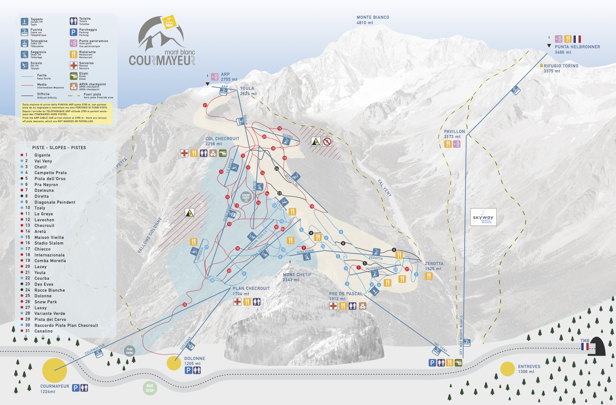
Trail Map
Courmayeur Trail Map
Ski Resort
Reviews
Trail Map
Snow Report
Weather
Webcams
Lift Ticket Prices
Home
Open Lifts & Slopes
Lift Ticket Prices
Skiing Lessons
Equipment Rentals
Ski Vacation
Photos
Wall
Trail Map
Interactive Map
Open Trails
Status
Name
Arp Nera
Arp Rossa
Campetto Prato
Canalino
Checrouit
Chetif
Chiecco
Comba Moretta
Courba
Des Eves
Diagonale Peindent
Diretta
Federica Brignone
Gigante
Internazionale
Lavechon
Lazey
Les Greyes
Maison Vielle
Pista del Cervo
Pra Neyron
Raccordo 19-20
Raccordo 21–20
Raccordo Piste Plan Checrouit
Rocce Bianche
Snowpark
Stadio Slalom
Stadio Slalom B
Tzaly
Val Veny
Variante Verde
Youla
Youla variante
Canalino variante
Checrouit variante
Dolonne
Dzeleuna
Lassy
Lassy variante
Pista Dell Orso
Pra Neyron variante
Raccordo 9 – 2
Stadio Slalom A
Val Veny variante
Source: INTERMAPS®
Open Lifts
Status
Name
Aretu
Arp
Bertolini
Checrouit
Chiecco
Courmayeur
Dolonne
Dzeleuna
Gabba
Le Greye
Maison Vieille
Peindeint
Pra Neyron
Prato
Tzaly
Val Veny
Youla
Zerotta
Le Greye
Source: INTERMAPS®
Advertisement
Advertisement
Lifts
18
3
8
2
4
1
Total
18
Skiable Terrain
42
km
Easy
Moderate
Advanced
Ungroomed
Overall Slope Length
42
km
Number of Slopes
45
Current Conditions
Open Trails
33/45
Open Lifts
18/18
max -1
°C
Snow Upper
cm
100
Snow Lower
cm
60
Last 48h
cm
10
Detailed snow report
5-Day Weather Forecast
Ski Resorts
Ski Resort Finder
Europe
Germany
Austria
Switzerland
Italy
Norway
France
Czech Republic
Finland
Sweden
Slovakia
Poland
Spain
Slovenia
Romania
Greece
Great Britain and Northern Ireland
Netherlands
Bulgaria
Belgium
Andorra
Ukraine
Serbia
Croatia
Liechtenstein
North America
USA
Canada
Asia
Japan
China
Russia
South Korea
Turkey
Georgia
Iran
Azerbaijan
India
United Arab Emirates
Oceania
New Zealand
Australia
South America
Chile
Argentina
Africa
Egypt
Nordic Skiing
Europe
Germany
Austria
Switzerland
France
Italy
Czech Republic
Norway
Sweden
Finland
Poland
Slovakia
Slovenia
Spain
Andorra
Liechtenstein
North America
USA
Canada
Oceania
Australia
New Zealand
South America
Argentina
Chile
Asia
Russia
Lodging
Europe
Austria
Italy
Germany
Switzerland
Czech Republic
France
North America
USA
Canada
Magazine
News
Top 10
Specials
Equipment
World Cup
Inside
Tips & Tricks
Ski Reviews
Skis
Ski Finder
Sort by category
All Mountain Ski
All-Rounder
Powder Ski
Junior Ski
Kids' Ski
Race Inspired
Race Ski
Sport Carver
Slalom Ski
Misc. Ski
Backcountry Touring Ski
Twin-Tip / Freestyle
Lady Ski
Sort by brand
Völkl
Atomic
Rossignol
Fischer
Elan
Dynastar
Blizzard
Head
Salomon
K2
Nordica
Stöckli
Kästle
Scott
Line
Black Diamond
Indigo
Hagan
Lacroix
Icelantic
DPS
Mountain Wave
Dynafit
Volant
Kessler
Zai
Ogso
RootAlpine
Foil
German
This website uses Cookies to ensure you get the best experience on our website
Data Protection Regulations
I got it
Ski Resort Finder
Ski Finder
Sweepstakes
Packages & Deals
Snow Ticker
Map
Login
E-Mail
Password
Login
Forgot your password?
Create new account